Canvas 14 review
DownloadNeed photo, graphics and drawing software that also supports GIS mapping file formats? Canvas 9 delivers.
|

|
Need photo, graphics and drawing software that also supports GIS mapping file formats? Canvas 9 delivers. It is trusted by organizations such as Boeing, NIH, and Chevron Texaco. Canvas supports 125+ standard, proprietary and scientific file formats.
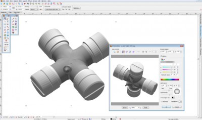
Canvas combines all the features of other graphics editors, illustration programs, and publishing tools. The updated, intelligent interface responds dynamically and presents you with the right tools at the right time, as you move through a project. This saves you constantly sorting through menu options to get the right tools.
If you can do it in other less-intuitive graphics programs, you can do it in Canvas faster and better. With its intelligent user interface and integrated design, there's no need to switch from one program to another and back again.
For example, to publish a full-color brochure, you would typically use a few different programs: one to edit images, another to design graphics, and a third to layout artwork and publish. Each at cost of up to a thousand dollars.
Canvas is the only cross-platform photo, graphics, publishing and drawing program that is seamlessly integrated. Get professional level photo editing, page layout, web graphics, and presentation features in a single creative application – all for a few hundred dollars.
Here are some key features of "Canvas":
2,104 Coordinate Reference Systems
67 Operation Methods (like Mercator, Albers Conic Equal Area?)
1,052 Map Projections
302 Geodetic Datums
21 Angular units
45 Length units.
Limitations:
15 days trial.
Canvas 14 search tags

